

A powerful 7.8-magnitude earthquake struck the southern Philippines on Monday morning, sending shockwaves across the region, damaging infrastructure, triggering tsunami warnings, and raising concerns over potential casualties. Authorities launched emergency response operations as residents in coastal communities rushed to evacuate following warnings of hazardous tsunami waves.
The earthquake occurred off the coast of Mindanao, one of the Philippines’ largest islands, and was among the strongest seismic events to hit the country in recent years. Initial reports indicated widespread panic, structural damage to buildings, power disruptions, and injuries in several affected areas. Officials are continuing to assess the full scale of the disaster.
Epicenter Near Mindanao’s Southern Coast
According to seismic monitoring agencies, the earthquake struck at approximately 7:37 a.m. local time near the southern coast of Mindanao. The epicenter was located offshore near Sarangani Province and close to General Santos City, a major urban center in the region. The quake occurred at a relatively shallow depth, increasing the intensity of ground shaking felt across nearby provinces.
Residents across Mindanao reported violent shaking that lasted for several seconds. Tremors were strong enough to be felt beyond Philippine borders, including parts of Indonesia and Malaysia, highlighting the earthquake’s regional impact.
Tsunami Warnings Prompt Coastal Evacuations
The earthquake immediately triggered tsunami warnings in the Philippines and neighboring Indonesia. Disaster management authorities advised residents living along vulnerable coastlines to move to higher ground and stay away from beaches and coastal areas until further notice.
Forecast agencies warned that tsunami waves exceeding one meter above normal tide levels could strike parts of the Philippines, while smaller waves were expected along sections of Indonesia and Malaysia’s coastlines. Emergency alerts were also monitored in several Pacific territories as authorities evaluated potential oceanic impacts.
Officials cautioned that tsunami activity could continue for several hours after the initial quake, urging residents not to return to evacuated areas prematurely. 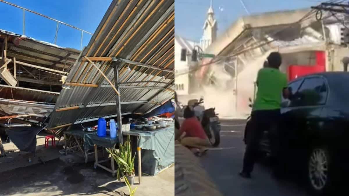
Damage Reported Across Affected Areas
Preliminary assessments indicated damage to buildings, schools, commercial establishments, and public infrastructure. In General Santos City and surrounding communities, reports emerged of collapsed structures, cracked buildings, fallen debris, and localized power outages. Emergency crews were dispatched to inspect roads, bridges, hospitals, and other critical facilities.
Several vehicles were reportedly damaged by falling debris, while educational institutions and public offices suspended operations as a precaution. The earthquake struck during morning hours when many residents were preparing for work and school, contributing to widespread disruption.
Authorities also warned of significant aftershocks, which could further weaken damaged structures and complicate rescue and assessment efforts.
Casualty Fears and Rescue Operations
While emergency officials initially struggled to verify casualty reports, authorities later began investigating reports of fatalities and injuries linked to collapsed structures and earthquake-related incidents. Rescue teams were deployed to affected communities to search damaged buildings and assist displaced residents.
Disaster management agencies emphasized that the casualty count could change as communication improves and assessment teams gain access to heavily impacted areas. The full extent of human and economic losses remains under evaluation. 
Government Response Intensifies
National and local authorities quickly activated emergency protocols following the earthquake. Government agencies coordinated with disaster response units, military personnel, and local governments to monitor affected regions and support evacuation efforts.
Officials ordered inspections of transportation networks, public infrastructure, and utilities to determine the extent of structural damage and ensure public safety. Classes and public activities were suspended in several impacted areas while emergency assessments continued.
Philippines’ Vulnerability to Major Earthquakes
The Philippines sits along the Pacific Ring of Fire, one of the world’s most seismically active zones. The region experiences frequent earthquakes and volcanic activity due to the movement of multiple tectonic plates beneath the Earth’s surface.
Large earthquakes are not uncommon in the country, but powerful events of this magnitude pose significant risks to densely populated coastal communities because of both ground shaking and the possibility of destructive tsunami waves. Experts note that preparedness, rapid evacuation, and resilient infrastructure remain critical factors in minimizing casualties during such disasters.
Situation Continues to Develop
As aftershocks continue and authorities conduct damage assessments, emergency agencies remain on high alert. Residents have been urged to follow official instructions, avoid damaged structures, and remain vigilant for additional seismic activity.
The earthquake serves as a stark reminder of the region’s exposure to powerful natural disasters and the importance of disaster preparedness across the Asia-Pacific region.
Leave a Reply