

A fast-moving wildfire in California’s Alameda County intensified rapidly on Tuesday, scorching hundreds of acres of dry grassland and prompting mandatory evacuation orders in areas near Sunol and Pleasanton.
The blaze, known as the Little Fire, was reported at around 2:45 p.m. near the intersection of Vallecitos Road and Little Valley Road in the Sunol area, south of Pleasanton. Within hours, the fire had spread across approximately 700 acres, with authorities initially reporting no containment as firefighters struggled to control the flames.
An update later indicated that the fire had expanded further, reaching about 950 acres by Tuesday night. Evacuation orders remained in effect across parts of southeastern Alameda County as emergency crews continued efforts to slow the fire’s advance.
Fast-spreading wildfire threatens communities near Pleasanton
The Little Fire’s rapid growth raised concerns because of its proximity to populated areas on the eastern side of Pleasanton. The blaze was burning through dry vegetation in a region where hot weather, low humidity and gusty winds created highly favourable conditions for wildfire spread.
Firefighters from multiple agencies, including the Alameda County Fire Department, the Livermore-Pleasanton Fire Department and state firefighting resources, were deployed to battle the flames. Crews faced difficult conditions as the fire moved quickly through dry grasslands.
The fire was reported to be burning near Vallecitos and Little Valley roads in the rural southeastern part of the county. Authorities continued to monitor its movement closely as changing weather conditions and wind patterns threatened to accelerate its progress.
The situation also generated concern because the fire was burning in the vicinity of a former nuclear facility. The company associated with the site said it was assessing the situation, while the local utility provider said the blaze had not affected its infrastructure at the time of the report.
Evacuation orders issued in several areas
As the wildfire moved toward areas with homes and other populated locations, authorities ordered residents in multiple evacuation zones to leave. The affected areas included zones identified as ALC-072, PLS-080, PLS-081 and PLS-103, covering parts of unincorporated Sunol and the Ruby Hill neighbourhood along Pleasanton’s eastern edge.
Evacuation warnings were also issued for zones PLS-079 and PLS-082 as emergency personnel worked to prevent the fire from spreading further into populated areas.
Authorities urged residents under mandatory evacuation orders to leave without delay and advised people in nearby communities to remain prepared for possible changes in evacuation instructions.
An evacuation mapping system estimated that the affected evacuation area could involve approximately 4,900 residents. At the time of the initial reports, however, officials had not provided a clear figure for how many people had actually left their homes.
Residents were encouraged to monitor official emergency alerts and local authorities for the latest information, as evacuation boundaries could change depending on the direction and speed of the fire. 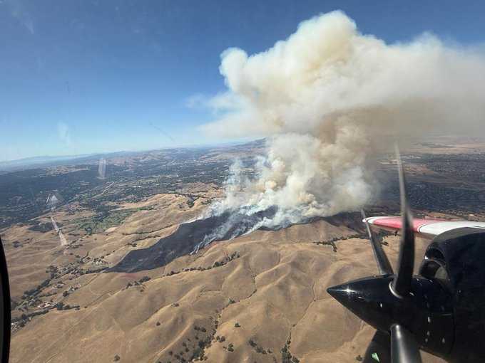
Roads and emergency shelters activated for evacuees
Highway 84, also known locally as Happy Valley Road or Vallecitos Road, was identified as an evacuation route for residents leaving threatened areas.
A temporary shelter was also made available at the Pleasanton Senior Center on Sunol Boulevard to assist people displaced by the wildfire.
Law enforcement officers were deployed to support evacuation operations and help emergency agencies manage the movement of residents from affected areas. Officials also appealed to the public to avoid using emergency police dispatch lines for routine wildfire updates, stressing that phone lines needed to remain available for urgent emergencies.
Although the fire was burning outside the City of Livermore, authorities said there were no evacuation orders affecting the city at the time of the report. Residents there were nevertheless urged to stay informed and remain alert to any changes in the situation.
Dramatic videos show flames and thick smoke
Videos and images circulating online showed large columns of smoke rising above the landscape as flames moved through dry vegetation. The footage highlighted the intensity of the wildfire and the challenging conditions faced by firefighters working to contain it.
Weather conditions were a major factor in the fire’s rapid development. Temperatures in the area were reported to have reached approximately 91 degrees Fahrenheit, or about 33 degrees Celsius. Winds of up to 15 mph, combined with very low relative humidity, created an environment in which dry vegetation could ignite and burn rapidly.
Fire behaviour remained active, with officials closely watching weather conditions that could influence the direction and speed of the flames.
Firefighters continue containment efforts
The wildfire’s rapid expansion underscored the difficulties emergency crews faced in gaining control of the blaze. At one stage, the fire had grown to hundreds of acres with containment still at zero. A later update indicated that some containment had been achieved, although the fire continued to threaten parts of southeastern Alameda County.
The immediate priorities for firefighters remained protecting homes and communities, supporting evacuation operations and preventing the fire from spreading further.
Authorities continued to urge residents in and around the affected areas to follow evacuation orders and rely on official emergency notifications for accurate information. As conditions remained fluid, officials warned that evacuation zones and safety instructions could change quickly.
The Little Fire adds to concerns about wildfire risks in California, where dry vegetation, high temperatures, low humidity and strong winds can create dangerous conditions for fast-moving fires. For residents in the affected parts of Alameda County, the focus remained on evacuation, public safety and the ongoing battle to bring the wildfire under control.